 |
| Devagiri Daulatabad Fort |
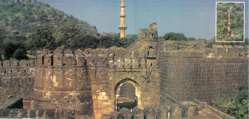 |
Devagiri (Daultabad of the later period), 11kms north-west of Aurangabad, is a famous for its formidable hill fort. The fort is situated on an isolated cone-shaped hill rising abruptly from the plain to the height of about 190 metres. The fortification constitutes of three concentric lines of defensive walls with large number of bastions. The noteworthy features of the fort are the moat, the scarp and the sub-terranean passage, all hewn of solid rock. The upper outlet of the passage was filled with an iron grating, on which a large fire could be used to prevent the progress of the enemy. The Chand Minar, the Chini Mahal and the Baradari are the important structures within the fort. |
The Chand Minar, about 63 metres in height, was erected by Alauddin Bahman Shah in 1435 AD to conquest of Daulatabad. Opposite the Minar is the Jumma masjid, whose pillars originally belonged to a temple. Close to it, there is a large masonry tank. The Chini Mahal at the end of the lower for is the place where Abdul Hasan Tana Shah, the last king Golconda, was confined by Aurangzeb in 1687 AD. Nearby is a round bastion topped with a huge canon with ram’s head, called Kila Shikan or Fort breaker. The Baradari, octagonal in shape, stands near the summit of the fort. The principal bastion at the summit also carries a large canon. |
| Though the city of Devagiri was founded in 1187 AD by the Yadava king Bhillan V, the fort was constructed during the reign of Singhana II (1210-46 AD). It was captured by Ala-ud-Din Kalji in 12 94 AD, marking the first Muslim invasion of the Deccan. Finally in 1318 AD, Malik Kafur killed last Yadava Raja, Harapal. Then in 1327 AD, Muhammed-bin-Tughluq sought to make it his capital, by transferring the entire population of Delhi and changing the name from Devagiri to Daulatabad. Then it was in the possession of the Bhamanis till 1526 AD. The fort remained in Mughal control till Aurangzeb’s death in 1707 AD., when it passed on to the Nizam of Hyderabad. The famous Ellora Caves are just 16kms away from Devagiri-Daulatabad. |
Pitcures: View of Devagiri for and its citadel (top left) from the top of its entrance gate (above), and the Chand Minar (inset). Country of the Jumma masjid, with old carved pillars (below, left), and the Kila Shikan canon with ram’s head (below, right) |
|
| |
|
|